Navigation Engineering & 3D Spatial Sciences

Navigation Engineering & 3D Spatial Sciences

Digital Twin Technology (3D-SAM)

3D-SAM delivers real world precision cooperative machine navigation using digital twin technology.

Our 3D-Spatially Aware Machine (3D-SAM) technology sets the new benchmark for modern object navigation in an interactive digital twin world, all in real time. For industrial applications, akin to modern 3D internet gaming technologies, our 3D-SAM Processors each loaded with high precision 3D-Model libraries, (survey grade), essentially become “multiple players” in a virtual 3D spatial environment. Like for any internet game, each player’s (mobile machine) spatial 3D navigation information is quickly distributed in through network communications to the other player (machines) 3D environments, all in real time.

For future machine automation and/or precision multi machine coordination projects, the 3D-SAM technology delivers real time 3D Spatial Artificial Intelligence (SAI) into each machine’s independent control system. Any machine (player), instantly is able to digitally perceive where it is in relation to other mobile machines (different players) and any stationary objects contained within the 3D digital twin environment. Human operators, via either by Augmented or Virtual Reality visualisation screens can also remotely “window view” the operating 3D-SAM environment as an observer.

For further technical information, investigate Technical Overview section.

For practical applications delivered to Australian Mining industry visit the sections below.

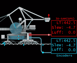
Today 3D-SAM is working at a number different locations within the Australian mining industry. Although these Gen2 technology versions are currently hosted exclusively on industrial Linux computers, the company is actively working on porting these successful designs across to more powerful Gen3.0 FPGA versions which will deliver huge increases in both processing speed and support much larger 3D environment sizes. Gen 3.0 versions are anticipated Q2 2018.

GNSS Encoder Calibration System (GECS) provides an alternative/ dissimilar technology measurement source for generating basic traditional machine navigation parameters, such as, machine body Long Travel + Structural Skew , and then, Slew + Luff values for any associated booms for Single 3D machines on undulating 3D rail networks. This information has traditionally been measured exclusively by electromechanical rotary encoders, RF tags, inclinometers etc. However, with the inclusion of 3D-SAM-GECS dissimilar technology, substantial operating efficiencies and reliability improvements can be realised.  Click for more background and technical overview material.

The multi machine BACS application of 3D-SAM, further extends the above GECS implementation to include full 3D spatial environmental information associated with multiple machine, while operational on 3D undulating rail networks. Essentially, a “multi player” (multiple machines) immersed in a 3D digital environment, where the intent is to continually monitor the spatial relationships of each machine’s external surfaces with respect to other machines and any static objects. BACS delivers a 3D spatial deterministic anti-collision system based on Spatial AI rather than traditional “rule based” approaches. Click for more background and technical overview material.

Applications in mining such as In Pit Crushing and Conveying (IPCC) require precise 3D positioning and orientation for each cooperative machine to ensure accurate/reliable ore transfer without the machines actually colliding. The 3D-SAM PMAS application provides all the inter machine IPCC spatial parameters all in real time, critical information required by both the machine’s individual control PLCs and the mine’s automated operational mining sequencing system. Click for more background and technical overview material.

The bulk materials operation’s penultimate aspiration is to precisely 3D map the changing bulk material stockpile shapes and volumes as the machines work to survey grade accuracies (centimetres). With 3D-SAM installations providing the very precise machine positions and orientations, integrating additional 3D/2D scanning perception technologies to capture the changing shapes delivers the required real timing mapping outcomes. RTSM provides a suite of 3D scanning hardware and software to achieve the required results. Click for more background and technical overview material.